
Big Disasters: The San Francisco Freeways
Big Disasters: The San Francisco Freeways
a disaster of design, engineering and planning
a disaster of design, engineering and planning
Only a fraction of the original plans were ever built, and a large portion where later torn down. What was planned, why they weren't built, and why the freeways turned out so Disastrous.
California's Division of Highways was busy building freeways before Eisenhower presented his 1956 National System of Interstate and Defense Highways plan, which paved the way for billions of new federal dollars to subsidize the automobile in the name of national security.
In 1940, Park Presidio Boulevard was built through San Francisco's Presidio to Golden Gate Bridge, creating the first roadway built to freeway definitions in Northern California.
California had determined that San Francisco not only needed highway connections to the north, east and south, but also crisscrossing paths of freeways throughout the City as well.
The war-era plans had some basis in Germany's efficient autobahns, but the American scale to freeway construction would vastly overshadow anything that existed in Europe. European cities, while connected by highways and often encircled by them, had never been bisected by elevated highway viaducts. Highway engineers in California were moving into new and uncharted territory.

By 1945, the state had laid out a web of planned freeway paths, although details changed frequently. In the winter of that year, construction started on what would become Highway 101, stretching south from Marin and north from San Jose.
A 1951 master plan hoped to snake the highway through San Francisco from the Central Skyway to the Golden Gate Bridge via Van Ness Avenue. In the middle of the City, a spur would split off and turn east to the Bay Bridge. Just before reaching the Bay Bridge, another spur would split off and head northeast, running up the waterfront past downtown. At some future point, this structure, called the Embarcadero Freeway, would continue north, serving as a second route through the City to the Golden Gate Bridge.
As construction of 101 proceeded north in the mid 50's, the Disastrousness of the plans became clear. The freeway north of Army Street was built as an overhead steel viaduct that split into a massive mess of freeway viaducts at the end of Potrero Avenue. And what had started in low value industrial land South of Market was now tearing through dense residential neighborhoods.

The double-deck concrete structure of the Central Freeway demolished a wide right-of-way through houses along Division and then Octavia. Over the next five years, other neighborhood groups realized that the same thing was slated for their front yards, as had been clearly laid out in the 1951 master plan. They revolted.
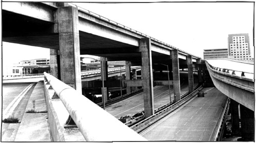
As they protested to save their neighborhoods, the Embarcadero Freeway was completed from the Bay Bridge to Broadway. The massive ramps of the Terminal Separator Structure were built on warehouse industrial land just south of Market Street.


The structure that continued up the waterfront past the Ferry Building replaced the City's Bay views with a sky darkening, dual-level elevated concrete viaduct.


In 1959, amid city wide protests to protect remaining neighborhoods and parks, the City's Supervisors voted to kill seven of the ten planned freeway projects in the 1951 plan. The portion of the Central Freeway continuing up Van Ness to Golden Gate Bridge was halted, as were plans to build several other crosstown routes.
These included a Western Freeway from Octavia through the Panhandle toward Golden Gate Park, a Mission Freeway to obliterate the sunny Mission District, and a Crosstown Freeway to cut across the hills northwest from San Jose Avenue to the Inner Sunset, where it would join the 19th Avenue freeway headed through the park.
Below is a drawing of the interchange planned between the Central Freeway and the never built Western Freeway.

After reaching the park, initial plans called for freeways on both sides of the park, and massive interchanges with a third northbound freeway running up 19th Avenue and fourth northbound freeway running up the beach. The freeways' threat to Golden Gate Park, and what remained of Hayes Valley, was a major impetus behind the Freeway Revolt.
Work on the Southern Freeway continued, and plans were drafted, but not completed, to connect the Golden Gate Bridge via Junipero Serra, 19th Avenue and Park Presidio with a freeway grade roadway.
Over the next three decades, other freeway plans were drawn up, including the reincarnated Golden Gate Freeway which would continue the Embarcadero Freeway through Fisherman's Wharf and the Marina to Golden Gate Bridge.

No new freeways were built beyond the routing of Interstate 280 in the southeast, which continued the path of the Southern Freeway toward the Bay Bridge. Today, occasional plans are revived to tunnel freeways, rather than build the overhead concrete and steel viaducts chosen in the 1951 plan. Tunneling is monstrously expensive and the construction required to tunnel major roadways can be disastrous to the neighborhoods it runs through.
Why a Disaster
The San Francisco Freeways were a Disaster in planning, engineering and design. The plans were Disastrous because they intended to solve one problem without considering what new problems they might create. The only costs recognized in the projects were that of demolishing houses and pouring concrete.
Further, there was no consideration to integrate freeway traffic into a larger transportation system, nor much thought given to building transportation systems that better fit in with their surroundings, nor much research and land use study to determine if laying miles of overhead concrete was even a worthy goal. The enormous costs to the City in depressed land values, increases in crime and urban decay went unforeseen.
As for engineering: traffic got worse. The Embarcadero Freeway was supposed to move cars from the City either east across the Bay Bridge or south along 101. Instead, it simply funneled traffic into bottlenecks in a way that degraded traffic, while at the same time inducing more people to drive when other options were available. Traffic actually improved after it was demolished.
Additionally, the Embarcadero and Central Freeways' design optimistically hoped that Californians would know how to merge into traffic better. Since their construction, segments of lanes have been painted out to force drivers to merge earlier and avoid clogging routes. This has narrowed the viaducts' capacity in an effort to reduce accidents and make traffic flow better.
And as for design: San Francisco's elevated freeways were not built to withstand a significant earthquake. In 1989, all of the elevated freeways were closed and most retrofit at enormous cost. Retrofitting is still underway twelve years later. Fortunately, their design problems allowed for the complete removal of the hated Embarcadero Freeway and much of the Central Freeway.
Disaster Recovery
Will it happen again, and has anything been learned? After the earthquake, while business interests downtown and in Chinatown, and the largely Chinese residents of the Richmond District fought to rebuild the Embarcadero and Central Freeways, the rest of the City demanded some rethinking on the matter. Some in the Chinese community even announced that removal of the freeway was racist.
Caltrans, the state's transportation office, was charged with handling the post earthquake damage, but chose only to repair or rebuild freeways along the unfinished design of the 1951 plan. There were no decisions to stop and significantly rethink City freeways or study any other transportation options that may be more appropriate.
That being the case, the City forced Caltrans to replace the Embarcadero Freeway along the waterfront with a surface boulevard and transit lanes, and is currently wrestling with them to start work on removing the remainder of the Central Freeway north of Market Street.
The old Central Freeway route will be replaced with a wide boulevard, and ramps at Market Street will allow freeway traffic to head east or west into Market Street, or north to Franklin Street, as well as northwest to Fell Street. The current freeway only pushes cars out at Fell.
In 1997, the lower deck of the Central Freeway was spared, due to hysteria that a freeway was the only way to move people. Supporters knew that if the freeway was ever torn down, it would never be rebuilt.
Caltrans did not offer to rethink transportation plans for the area. Instead, they took the opportunity to spend millions of dollars to retrofit the remaining segment of the Central Freeway, including its obsolete spurs designed for the Western Freeway and its continuation north to Van Ness.
Caltrans was banking on rebuilding the Central Freeway as a wider, but shorter viaduct that crossed Market Street as a double-wide, rather than double-tall freeway. San Franciscans rejected the wider freeway, and introduced the new plan to drop the freeway at Market and build a new Octavia Boulevard. Caltrans was forced to draw up new plans for the shorter structure.
Five years later, the old mile long, retrofit onramp still stands above a dirty Octavia Street as the City and Caltrans discuss how to handle the land underneath it.
Even the remarkable success of the Embarcadero demolition hasn't entirely erased the fear and paranoia that removal of a freeway is anything but calamitous. San Franciscans should know better. Interestingly, other cities are following the example made by San Francisco's earthquake, and are working to voluntarily remove their own inner-city freeways.
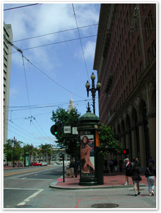
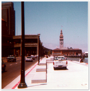
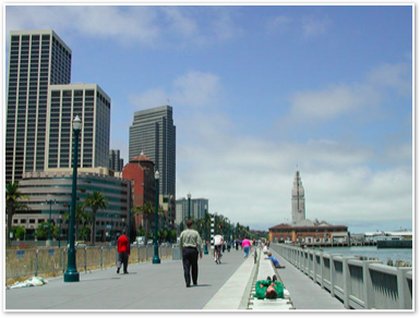
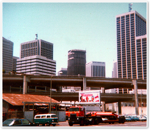
Here are some before and after photographs of the Embarcadero Freeway.
Before pictures courtesy Michael Kiesling of Architecture 21
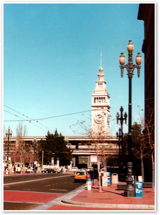
Market Street looking east to the Ferry Building.
Looking north toward the Ferry Building.

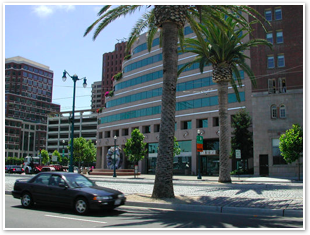
Looking west toward what is now Bayside Plaza.
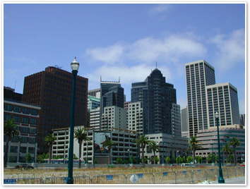
Looking northwest toward what is now Ricon Towers.
More on Roads and Cities:
Flattened Fauna
National Geographic's Guide to Scenic Highways
Many More Roads
Thousand Roads
How Cities Work: Suburbs, Sprawl, and the Roads Not Taken
The Car and the City
Alternate Route: Toward Efficient Urban Transit
Sustainability and Cities
The Transit Metropolis: A Global Inquiry
Flattened Fauna
National Geographic's Guide to Scenic Highways
Many More Roads
Thousand Roads
How Cities Work: Suburbs, Sprawl, and the Roads Not Taken
The Car and the City
Alternate Route: Toward Efficient Urban Transit
Sustainability and Cities
The Transit Metropolis: A Global Inquiry


 |
|
 |
|
 Del.icio.us |
 Technorati |
About RDM |
Forum : Feed |
Technorati |
About RDM |
Forum : Feed |
 Send Link
 Reddit
 Slashdot
 NewsTrust
Monday, August 20, 2001


